Anyone else getting "current news" tiles on their PC's and phones warning of impending tropical storm and hurricane strikes that already happened back in August and September?
These started this morning. All are coming from Florida newspapers, and some state things like begin hurricane or flood preparations now.
Tropical storm Fred and Hurricane Larry did not exist at the same time, but they appear on the same screen in the first picture.
I grabbed my camera and took a couple pictures of my computer screen. All of the other "stuff" appears current.
Attachments


George,
Click on it and see if it is indeed dated when you say. If so, they are leaving it there as a story of significant interest on a current page. Happens here too.
Click on it and see if it is indeed dated when you say. If so, they are leaving it there as a story of significant interest on a current page. Happens here too.
Well after a couple of frosts that killed all the flowers in the garden it's gone mild again (12-14C each day) which is odd for the middle of november. I'm still in shorts. usually by bonfire night (5th nov) we are getting regular hard frosts.
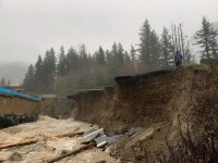
Chris, we’ve not seen the likes of this before. Thousands and thousands of people affected and more to come. Right now we are okay and should stay that way but it does mean we are on stand by for helping others.
Take care my friend, this is unprecedented.
Hope you are safe and doing well.
Take care my friend, this is unprecedented.
Hope you are safe and doing well.
Glad you're doin' ok Cal. My wife showed me a video on her phone this afternoon of a guy in what appeared to be a jet boat blasting thru downtown Abbotsford.😱
jeff
jeff
Yup, we’re now experiencing “once in a ———” (pick your own qualifier) events every few months now; it’s almost like Mother Nature is trying to teach us something, that in our hubris we might not learn or act on on time.
At least for a while.😉 I took Ringo out for a walk about an hour ago. Really quite pleasant out, clear sky's with a bit of a breeze.
No doubt there are a few flooded basements in the neighborhood though.🙁
jeff
No doubt there are a few flooded basements in the neighborhood though.🙁
jeff
Last edited:
Looks like a switch from roofing to culverts might be a good move, Cal.
Remember, Bugs Bunny gave us the only weather report we really need:
"Scrrr..ewwy, ain't it?"
Remember, Bugs Bunny gave us the only weather report we really need:
"Scrrr..ewwy, ain't it?"
Jeff, you took Ringo, I just came in with Bingo and we both had clear skies. Wind is down a bit as you said.
Boswald, the roofing industry makes a lot of money after storms like this obviously. It’s sad for those who suffer but from bad comes some good.
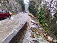
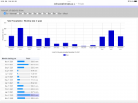
No kidding. Almost 100mm of rain in 24 hours is certainly unprecedented for Victoria.
jeff
I think the latest count was circa 150mm, on top of the several weeks of higher than normal. One of our favourite storm watching spots on the island is Tofino, which so far this month has accumulated about 20mm less than the entire month of November last year. They don’t call this the wet coast for nothing.
If it wasn’t so scary, tracking the intensity and width of this latest storm track on the weather radar app would have been fun. Historical records are not the only things being devastated all over the place. The property insurance industry will be interesting to watch in the coming years.
Cal, it only takes one poorly sealed penetration by an HVAC contractor on a restaurant’s flat T&G flat roof to ruin your day. As you well know, water goes wherever the hell it wants to, and is not always predictable or easy to trace.
Attachments
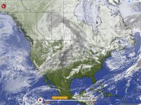
Chris, Do you do Windy? I don't have time right now but see if this will allow you to go back in time?
Windy: Wind map & weather forecast
Windy: Wind map & weather forecast
Watching the news, definitely the 100+ year event situation. Do time, to re-drawing the flood plane maps again. I hope everyone is safe and the searches of the debris fields come up with only mud, rocks and trees. Infrastructure is going to take a while to get back up and running again.
Boswald, the roofing industry makes a lot of money after storms like this obviously. It’s sad for those who suffer but from bad comes some good.
After "Super Storm Sandy" (which removed half of our roof in NJ) my fella who maintains the trees told me: "This storm is sending my three kids to college!"
Chris, Do you do Windy? I don't have time right now but see if this will allow you to go back in time?
Windy: Wind map & weather forecast
Yes, but I try to apologize when it’s not discrete, and blame it on Susan’s cooking. 😱
Seriously, though, it’s always interesting and entertaining to watch the interaction of the global patterns, and particularly to toggle to the satellite views. Currently we’re having a bit of a “nice sunny day”.
Attachments
I think the latest count was circa 150mm, on top of the several weeks of higher than normal.
Most likely rainfall measured at the airport. I get my numbers from the Uvic weather station at Torquay Elementary. Who knows how accurate their rain gauge is?
And yes, it's a lovely day here. If you didn't watch the news, you'd think everything was back to normal.
jeff
Last edited:
- Home
- Member Areas
- The Lounge
- The Weather