Yeah I know, I just threw it into the mix....Richard C Hoagland the proprietor of this site is described as a conspiracy theorist and fringe pseudoscientist by by others and as "a unique mixture of amateur scientist, genius inventor, scam artist, and performer, blending true, legitimate speculative science with his own extrapolations, tall tales, and inflations." by the publisher of his books.
Mr Hoagland received the Ig Nobel Prize for Astronomy in 1997 for 'identifying artificial structures on Moon and Mars including a face on Mars and ten-mile high buildings on the other side of the moon'.
The presentation of these traditionally ends with the sentence "If you didn't win a prize but especially if you did: Better luck next year!".
Dan.
I just hope Max didn't waste his time reading it.....
Easy to find this...
By 2012 several papers by different groups, all reanalyzing the thermal radiation pressure forces inherent in the spacecraft, showed that a careful accounting of this explains the entire anomaly, and thus the cause was mundane and did not point to any new phenomena or need for a different physical paradigm.
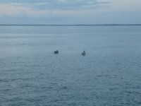
Ah ah! Had a good telephoto video day. I live on a river where we have 3 bridges nicely spaced for curvature experiments. I shoot video from the "bottom" (south) bridge looking north. There is the midpoint bridge at 3.2 miles and the top bridge at ~7 miles distance. Superb for looking at curvature. Since to bridges are at the same distance off the water, they should line up on a flat earth - do they?
It's very difficult to get clear video over 7 miles of open water. The air is so shimmery that everything looks like an impressionist painting. Today's results where the best I've gotten in years. FWIW, the field of very of my looong Canon zoom is just under 1 degree wide. That allows me to see car and truck traffic on the bridges at 3.2 and 7 miles distance to determine the bridge alignment.
It's very difficult to get clear video over 7 miles of open water. The air is so shimmery that everything looks like an impressionist painting. Today's results where the best I've gotten in years. FWIW, the field of very of my looong Canon zoom is just under 1 degree wide. That allows me to see car and truck traffic on the bridges at 3.2 and 7 miles distance to determine the bridge alignment.
video here:
https://youtu.be/xcCBhJbCxX8
You can just see the traffic on the far bridge climbing up the tall part on the right. It's under the near bridge.
https://youtu.be/xcCBhJbCxX8
You can just see the traffic on the far bridge climbing up the tall part on the right. It's under the near bridge.
Attachments

Please forgive me if I've missed something along the way. But Pano's (and others') noble efforts notwithstanding, it seems a turn was missed a few miles back, whereby this discussion would have logically progressed from astronomy to human psychology?
signed,
Barney Buzzkill
signed,
Barney Buzzkill
How do the FE brigade explain the why the moon looks different - rotated - as you move from north to south of the globey thing?
True, but this one is very flat and the drop is very gentle. It is flat Florida after alll. I just flew over those bridges an hour ago. Looks flatI would think rivers wouldn't be ideal because they flow 'downhill'.
Plus, I'm looking up river in the video, so that would tend to flatten things.
Can anyone make out anything in my wavy video?
I recognize that location since I have been there many times. My parents lived in St. James City for about 10 years back in the 70's - 80's. I sailed those waters in my 14 foot Hobie Cat often.
Many of my "Florida" pictures were taken around Redfish Pass, many with the same Panasonic camera used to take the "curved earth" pictures out of the airplane window I posted previously.
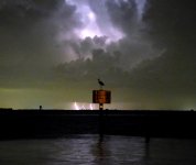
If I stand on the northern tip of Captiva Island and look due east do I see Pine Island (6 miles)? The tree tops and a few rooftops are visible when back lit by sunrise. It is mostly low land and the ground is at or beyond my horizon. I can, however on a clear day make out some of the tall buildings on the southern tip of Cape Coral and Shell Point (10 miles). The light atop the 1000 foot broadcasting tower east of I-75 is visible (about 30 miles), and I have several pictures of it being hit by lightning.
Radar revealed a strong thunderstorm east of Ft. Meyers. It was not raining on Captiva and no storm showed on radar over Pine Island. The big spark is in the direction of the old Qualcomm tower east of Ft. Meyers. Originally built for Qualcomm's failed Media Flow service, it is now used for TV and cellular service.
What do I really believe.....as a person who sailed or power boated into Miami (Coconut Grove Marina) from Bimini, about 60 miles, I can tell you that sailing by compass will send you too far north due to wind and the gulfstream's current. Sail at about 240 degrees and look for the landmarks. The first landmark was the WQAM radio tower (the tallest tower in the 60's). Then you looked a little to the south and found the multiple towers of WIOD radio, about an hour later at 7 knots. (not as tall but there were several) We would use an old transistor radio to null these stations, to know where to look. WQAM could be heard in Bimini 24 hours a day (clear channel station). WIOD cut power or changed aiming at night. The lighthouses at Cape Florida and Fowey Rocks would not be visible for a couple more hours. The two radio towers are gone now, not sure about the light houses or other old landmarks. I haven't sailed the bay in nearly 40 years.
If the world were truly flat, you could just look for the tallest building, since they should all be in view, if not obstructed by something else. Why would the blinking red light on the top of the WQAM tower be the first thing visible on the western horizon at night. It would take some time before the second set of lights become visible.
Many of my "Florida" pictures were taken around Redfish Pass, many with the same Panasonic camera used to take the "curved earth" pictures out of the airplane window I posted previously.
If I stand on the northern tip of Captiva Island and look due east do I see Pine Island (6 miles)? The tree tops and a few rooftops are visible when back lit by sunrise. It is mostly low land and the ground is at or beyond my horizon. I can, however on a clear day make out some of the tall buildings on the southern tip of Cape Coral and Shell Point (10 miles). The light atop the 1000 foot broadcasting tower east of I-75 is visible (about 30 miles), and I have several pictures of it being hit by lightning.
Radar revealed a strong thunderstorm east of Ft. Meyers. It was not raining on Captiva and no storm showed on radar over Pine Island. The big spark is in the direction of the old Qualcomm tower east of Ft. Meyers. Originally built for Qualcomm's failed Media Flow service, it is now used for TV and cellular service.
What do I really believe.....as a person who sailed or power boated into Miami (Coconut Grove Marina) from Bimini, about 60 miles, I can tell you that sailing by compass will send you too far north due to wind and the gulfstream's current. Sail at about 240 degrees and look for the landmarks. The first landmark was the WQAM radio tower (the tallest tower in the 60's). Then you looked a little to the south and found the multiple towers of WIOD radio, about an hour later at 7 knots. (not as tall but there were several) We would use an old transistor radio to null these stations, to know where to look. WQAM could be heard in Bimini 24 hours a day (clear channel station). WIOD cut power or changed aiming at night. The lighthouses at Cape Florida and Fowey Rocks would not be visible for a couple more hours. The two radio towers are gone now, not sure about the light houses or other old landmarks. I haven't sailed the bay in nearly 40 years.
If the world were truly flat, you could just look for the tallest building, since they should all be in view, if not obstructed by something else. Why would the blinking red light on the top of the WQAM tower be the first thing visible on the western horizon at night. It would take some time before the second set of lights become visible.
Attachments


Pano, in your video it looks to me that the bottom of the pylons meeting the water are not visible, and are hidden by the curvature of the earth.
Hey George, we seem to run in the same circles, years apart, Lauderdale, Boyton, Ft Myers. I'm in Charleston WV today, might have flown over your holler this morning. Nothing flat about West Virginia, that's for sure. The midpoint bridge in the foreground of my video probably wasn't there when you sailed the river. The radio towers are still there. Good lightening pics, thanks!
Gimp. Yes, the pylons of the near bridge are at 3.2 miles. My camera was 6 feet above the water, which would put the horizon at 3 miles. The are just barely obscured.
If you can see the far bridge, that's the interesting part. Look for the traffic on it, toward the right of the frame. At 7 miles distant, 12 feet of that bridge should be obscured. You'll see the inversion near the water, it looks like a smeared reflection. This was about 6PM, I shot video at 8:30AM and the inversion was much worse, could not see the far bridge at all.
Many of the flat earth proofs and experiments hinge on a stretch of water being either flat or curved. You need about 5 miles to get good results, which is what I did in England. Here it's 7 miles.
Can anyone make out anything in my wavy video?
Yes, is that an inversion and reflection of the far bridge? Why does it vary from end to end?
The far bridge is not flat to the camera. The left end is farther away. And on the right you see it climb to the high spot for boat clearance. Where the traffic hits the horizon is the main, flat span. It's like the bridge in the foreground.
Ah, right, I did wonder, I was planning to have a look at it on google earth, but........er..........................couldn't be asked in the end........and......it might have been fake news anyway, ha!
I'm in Charleston WV today, might have flown over your holler this morning.
I'm about 160 miles north of Charleston, near Wheeling.
The midpoint bridge in the foreground of my video probably wasn't there when you sailed the river.
I don't think it was. If we came from Palm Beach we crossed the state on 80 and crossed the Caloosahatchee on route 31 to 78 to get to Pine Island. I-75 was not finished, so coming from Broward meant a trip across Alligator Alley to 41 then up to 78. I remember using the route at the south end of Cape Coral on holidays because it was faster. 41 can be slow.
The two radio towers are gone now, not sure about the light houses or other old landmarks.
I was referring to the radio towers that actually stood in the waters of Biscayne Bay (Miami). The WQAM tower stood right behind the Miami Herald (newspaper) building. It came down when the Miami Bayfront Park area got renovated (80's?) It wasn't there when I went to the last Miami Grand Prix (2003).
I know the WIOD towers were taken down when Stiltsville was in the process of a battle between the preservationists who called the houses on stilts in the bay historic, and the "clean up the bay" effort who called them gross polluters. In the 60's it was legal and common for boaters and Stiltsville residents (few other than the radio station) to flush raw sewage directly into the bay. The water at the north end was brown and stinky....but that didn't stop some of us from wading waist deep through it to sneak into concerts at the Dinner Key Auditorium, a converted sea plane hanger that still had the airplane ramp into the bay.
The boat we lived on in Boyton in the 70s had direct flush to the sea. No worries, the catfish ate it all up. 😀

- Status
- Not open for further replies.
- Home
- Member Areas
- The Lounge
- Flat Earthers