The folks from Ohio Edison were in our part of NJ with long fiberglas poles moving "hot" wires. We had crews from Pennsylvania, Ohio, Michigan.......
After hurricane Wilma leveled most of South Florida's electrical infrastructure in 2005 we had crews from 14 states with just about as many different repair techniques. We were without power for 22 days. We got power by feeding some Duke Power (North Carolina) guys pizza and beer. Then I took them directly to the fault and assured them that I had surveyed the entire lateral and this was the only fault. We had power in a couple hours.
Yupp, folks will take a 5kW generator and hook it into the laundry room "box" and fail to flip the "main" house breaker.
Usually the power guys will walk the line before messing with it and flip the house breakers if they hear a generator running. They do this to protect themselves from idiots. That's how I met the Duke Power guys. They heard my generator and walked toward my house. I explained that I ran 4 or 5 major things with extension cords, and had my pool pump powered up with a piece of 240 volt Romex that had alligator clips on the ends. After we had a good laugh, some pizza and beer, I took them to the downed pole with the 7200 volt lateral in a swimming pool.
A co-worker had dim lights in his house off and on during the power outage. At the moment his power was restored he heard a loud buzzing followed by a kaboom and a lot of smoke. Upon investigation he found a bewildered neighbor with a generator on fire. He kept saying "I don't understand, it wasn't even on" in broken English.
No problem with power here fortunately, although a lot of people in Plymouth and the deep south shore once again lost their power. My father in law has been without power for most of the past two weeks, and this storm took it out again. Average time to restore in his neighborhood is 4 days.
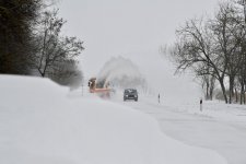
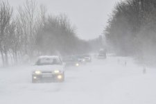
It was well above freezing at the start of the storm here just south of Boston, and it rained/sleeted well into Tuesday morning. The heavy snow started around drive time yesterday, by the time it was said and done I guess we got something between 10 - 12 inches on the ground. Strong winds deposited a great deal of snow in the trees all the way to the trunks.
I shoveled and snow blowed this morning and revealed a thin layer of slush that the snow had insulated which immediately started to freeze upon exposure. Scraped that off quickly.
It is now well above freezing and the stuff is starting to melt. I suspect it will be gone in a few days.
Sunny!
The last two weekends we had mild weather with moderate breezes and no rain, so I was able to till my garden. Last weekend I put in onions and Broccoli sets. Hopefully they will survive the high 20s nights we have been having.
We had snow yesterday, and it was 27 this morning and supposed to be in the 50s today.
It looks like spring is going to be a roller coaster ride this year.
We had snow yesterday, and it was 27 this morning and supposed to be in the 50s today.
It looks like spring is going to be a roller coaster ride this year.
I guess I had better batten down the hatches as it were.
Bureau of Meteorology - New South Wales Severe Weather Warning 1Weather Situation: A coastal trough will develop along the central parts of the coast over the next few hours, cradled between two strong high pressure systems. This will bring widespread rainfall to Newcastle, Lower Hunter and Central Coast from early Wednesday. These areas will see some very intense bursts of rain creating dangerous conditions.
HEAVY RAIN which may lead to FLASH FLOODING is expected over Newcastle, Central Coast and Lower Hunter during Wednesday.
100mm to 200mm is expected over the warning area during Wednesday. Some locations may receive more than 200mm.
...shorts and a T.
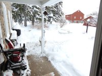
My plans include slippers. LL Bean calf-high insulated slippers. Meaning I don't need the snow-boots this time. As of 11:30EDT we have 3" on ground and another inch coming, all well below freezing so light and fluffy. Wind is significant but just annoying (blowing powder in wind, it all comes back onto my beard).
Near Quakertown PA the number is 14" and my kin in the hills may have more {picture}.
Attachments

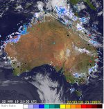
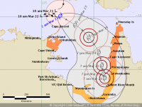
Got quite a bit of rain going on here. In the picture the TC Cat 4 Marcus isn't visible as its out of frame to the left.
Marcus isn't much of a concern at the moment as its expected to weaken before it gets any closer to the coastline. However TC Nora is expected to do some damage to the top end:
Tropical Cyclone Forecast Track Map
Thankfully we have a break in the rain where I am so I'm going to go down and work on my car.
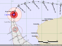
Attachments
Last edited:
- Home
- Member Areas
- The Lounge
- The Weather