The claimed record altitude of SR-71 is 16.11 miles, so "16 miles" is allowed for non-hotshot flying.
The SR-71 has beaten 2 hours New York to London. Concord has cracked 3 hours, 747 tends to a bit over 6 hours. (However the liners take off and land. The SR-71 burns or leaks so much fuel getting off the ground that it has to take on more fuel in the air.)
The SR-71 has beaten 2 hours New York to London. Concord has cracked 3 hours, 747 tends to a bit over 6 hours. (However the liners take off and land. The SR-71 burns or leaks so much fuel getting off the ground that it has to take on more fuel in the air.)
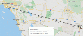
....Google Maps says there are 484 miles of Interstate road (which is certainly NOT a perfect straight line) from Tucson to Los Angeles....
G-Maps has a Measure Distance function which plots a straight line.
Attachments
There are plenty of Earth curvature calculators online, if you don't want to do the trig by hand.
And FWIW, taking off from the Gulf coast of Florida on can easily see across the state far out into the Atlantic before ever reaching cruising altitude. It looks quite close. But then Florida isn't very wide.
And FWIW, taking off from the Gulf coast of Florida on can easily see across the state far out into the Atlantic before ever reaching cruising altitude. It looks quite close. But then Florida isn't very wide.
compare with post #4
Yes, a pilot's-special map. Maybe I could find it. But I was plotting a 50 foot property setback, in plain G-Maps, and wondered if it went further.
The 12 mile discrepancy, 451/439, is odd, but I didn't drop my dots carefully.
My dots are between the Tuscon airport and LAX. Yours are closer to (roughly) Davis-Monthan AFB and Los Cerritos / North Long Beach neighborhoods. Pretty close, all things considered.
We have had a lot of U-2 and Sled drivers at my airline.
One wall of our training center: that’s a real David Clark S1030 pressure suit
View attachment 825739
One wall of our training center: that’s a real David Clark S1030 pressure suit
View attachment 825739
Attachments
- Home
- Member Areas
- The Lounge
- How far away is the horizon in a high altitude spyplane?

