This morning's models show Irma going up the east coast of Florida, which is about what I figured. That's going to be a disaster, as it's a heavily built and populated area. We'll get bad weather here on the gulf coast, but it shouldn't tear up too much on this side.
Let's hope it stays offshore, at least.
Let's hope it stays offshore, at least.
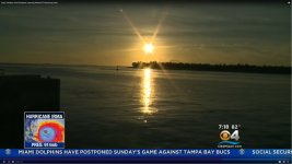
I grabbed this screen shot of the calm before the storm in Key West last night.
It was a beautiful sunset shown during a news broadcast from Miami TV channel 4 from an otherwise abandoned Mallory Square in Key West Florida. All tourists have been evacuated and unlike years in the past, most of the locals have boarded up shop and headed north. The beaches of Miami and Fort Lauderdale are also under a mandatory evacuation order and TV news from them showed a rather deserted Miami Beach this morning.
Oddly enough there is talk of flooding here from the remnants of Irma if it takes it's projected path with landfall somewhere in the Carolinas.
Hugo hit the Carolinas hard in 1989, but caused some severe flooding here in West Virginia as well as several other states before leaving the US to cause trouble in Canada.
Harvey's remnants caused some localized flooding as far north as Tennessee and Kentucky, but was mostly dissipated before it got here. We just got some heavy rain.
Attachments
Lovely clear day here on the gulf coast, as witnessed by this birdie in our yard this morning. The sort of day that might make you think "Hey, I maybe I'll go on a 3 day sailing drip to the Keys". Very happy we have storm warnings these days. Not a luxury our ancestors had.
Attachments


If it hits NYC we may get something up here as well.
If it hits NYC, will be living with a tarpaulin on the roof for the next 9 months!
")
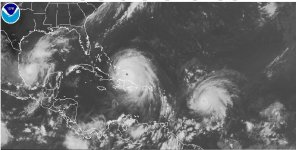
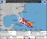
I screen grabbed the satellite image from the NOAA website. Irma is the big storm in the center, and Jose is to the right and slightly south of Irma. Katia is the fuzzy blob surrounded on 3 sides by Mexico.
Irma is about the same size as Florida, and the hurricane force wind field is about twice as wide as Florida.
The current forecast track has Irma running the entire north - south length of Florida, continuing on through Georgia, Tennessee, and into Kentucky with tropical storm strength or higher. It could travel into and possibly through Ohio although forecasting storms that far out is essentially guessing.
Attachments
After hurricane Juan i spent a few weeks cutting up the trees that blew down on our 1.7 acre lot. Then i hired a guy with a portable bandsaw mill, in the end i got over 400 sticks of lumber.
It was stickered and air dryed for 2 years and still have some left 14 years later.
It was stickered and air dryed for 2 years and still have some left 14 years later.
1 degree wide, or about 80 statute miles.
The weather guy on Miami TV channel 4 stated that hurricane force winds extend about 80 miles in either direction from the center, so I guess that's the same as what you say. What happens depends on the track of the storm, and that is still a guess, a guess with a lot of work behind it, but still a guess.
Either way, these guys are wrong just as often as they are right......except sometimes people die when they are wrong.
Hurricane Katrina is widely remembered for the mess that it made out of Louisiana, but nobody remembers the 11 people who died in Florida. Some of those died because the storm was forecasted to go west across the state after hitting Florida between Miami and Ft. Lauderdale.
I was outside during the storm removing a downed tree branch (same tree from post 9) from my air conditioner when the wind died off and never came back. Upon returning to the TV set, I had found that the storm made a turn to the south. This was unexpected and the order was not given to evacuate the people living aboard boats in Biscayne Bay. Several boats were capsized with people in them and some did not make it out.
Wilma (post #9) was predicted to be a minimal hurricane, as were most storms that came across the state from the gulf. The TV guy had said that shutters might not be needed. Since I had to pay about $2K to buy "approved" shutters to keep my hurricane insurance, (my DIY shutters weren't "approved") I was going to use them.....good idea!
Note that most of the houses in my pictures were not shuttered or boarded up. That's why some of the roofs failed. A window facing the storm breaks, wind pressurizes the house and the roof panels blow off. If you look at the picture of the roof failing in post 9 you can see that the garage window was left open, and the garage roof is what failed. The resulting wind and water made a mess of the entire house.......then the black mold set in.
We found out during that storm that a huge amount of wind goes between the houses where that window was left open. It turns out not to be a good place to stuff your car. A car across the street ended up with a large tree branch on top of it. The branch was not from any tree within several houses in any direction. Another car had moved several feet from wind, and had become wedged up against the house. The red SUV in my front yard had slid at least a foot down the driveway. It rocked from side to side during the 15 minutes of terror associated with the eye wall.
Last edited:
This one is a monstah
In St. Pete, west coast. I wasn't going to put the plywood over the windows yesterday, but changed my mind and will board up my mother's and my own home tomorrow. Nobody really has a handle on this one. Stay as safe as you can fellow Floridians.
Terry
In St. Pete, west coast. I wasn't going to put the plywood over the windows yesterday, but changed my mind and will board up my mother's and my own home tomorrow. Nobody really has a handle on this one. Stay as safe as you can fellow Floridians.
Terry
That's what worries me, wind direction
Assuming the storm takes its predicted path up the center of the state, the wind will come from the west as the storm approaches your latitude. When the storm is at the same latitude as you the wind will be from the north. After the storm passes your latitude the wind will come from the west. This may cause a storm surge that raises the water level in the river.
The NOAA web site now shows storm surge watch for Lee county. Miami TV as of 8AM puts Lee in the medium risk for storm surge.
Water flow in and out of the Caloosahatchee river may not be normal since sand and debris may clog some normal passages.
There is a huge tidal flow in and out of the river through San Carlos Bay and Pine Island Sound and into the gulf on a normal day. When hurricane Charlie came through in 2004 it hit Captiva Island directly. The resort where we usually stay was completely destroyed and was closed for two years to rebuild.
Charlie moved so much water and sand through the channels and passes that blind pass between Sanibel and Captiva was completely closed and impassable even on a jet ski. All the other channels were impassable by anything that drew more than 6 to 8 feet of water. They even had to re-dredge the channel under the Sanibel bridge.
We did not go the Captiva in 2005 since most of the island was still closed.
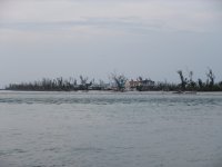
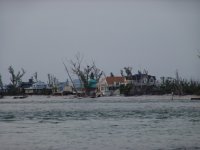
North Captiva is an exclusive island only accessible by barge, boat, or airplane. There is no bridge to North Captiva. I have been there once on a jet ski. It's southern tip can be seen from the north end of Captiva. These pictures were taken almost TWO YEARS after the storm. The houses haveb een rebuilt, but the trees tell the tale of what happened there.
HURRICANE IRMA
This is where most of the TV guys get their basic information. Major market channels have their own meteorologists and don't always agree with each other. I used to rely of Miami CBS channel 4, but all of the people have changed since I went through a major hurricane. Their good guy is now on the Weather Channel which is now owned by IBM.
Attachments
A window facing the storm breaks, wind pressurizes the house and the roof panels blow off.
This is usually caused by the pressure build up in the attic cavity through the soffit venting, not the windows unless it is an unfinished ceiling. Overall though the idea is the same as you state and it is a garage so...
- Status
- This old topic is closed. If you want to reopen this topic, contact a moderator using the "Report Post" button.
- Home
- Member Areas
- The Lounge
- Irma -- taking the toll